Showing posts with label science. Show all posts

Wednesday, April 1, 2020

It's Water-Wise Wednesdays with Frannie the Fish! {At Home Learning: You Be The Judge}

Water is an essential part of our everyday life. Water resource managers, city utility personnel, water well professionals, and more go to work every day to make sure we all maintain access to our clean water, even in uncertain circumstances.

Sometimes they are faced with hard decisions: Should water use be restricted? Should a certain amount of water be allocated to certain people or to everyone? In the following activity, you will be provided scenarios and you get to decide who should get the water. You be the judge!

Here's what you need:
  • Pitcher filled with water
  • Cups for each participant
  • Water use cards - you can copy or print the cards found in the activity instructions or make posters representing different water uses
  • Scissors 
  • Poster board (optional)
  • Markers (optional)  

Here's what you do:  
1. Fill a pitcher with water. Make sure there is a limited amount of water so that not all cups can be filled.

2. Give each participant a cup.

3. Pass around the pitcher so each participant can fill their cup. A full cup represents enough water for the participants to meet their water needs.


4. Sometimes there is not enough water available for everyone's needs - in times of drought for example. Ask the participants to express how they feel.

5. Ask what they could do to make sure they all get water.

6. Repeat steps 1-5, this time with water allocations. Choose one or combine both of the following options:
  • First in time, first in right. Have the participants arrange themselves in order by their birth date.   
  • Use the water use cards found in the activity instructions to determine how the water is distributed. Randomly pass out the cards. Participants can use the information on the cards to discuss and campaign for more water or why others should get more and some should get less.


7. Discuss the resultsother ways the water could be allocated, and what the participants learned about water use
  • Those with more important uses get more. Who decides what's more important?
  • Equal shares: everyone gets some, but some will get less than what they need.
  • Apply water restrictions and use water conservation practices to reduce the amount needed/used.
Share what you learned with the Groundwater Foundation!

Wednesday, February 19, 2020

It's Water-Wise Wednesdays with Frannie the Fish! {Video Learning Series: Groundwater Education Toolkit Training Videos}

This is the fourth blog in a series of video learning opportunities from the Groundwater Foundation. Click to see the previous blogs on the Groundwater Foundation, how the Awesome Aquifer Kits are made, and the Groundwater Guardian program.
---
Groundwater education is so important in the process of protecting this precious resource. Integrating the Groundwater Foundation's educational tools is easier than ever with a new series of training videos.

Each video focuses on a different resource within the educator toolkit. The first video in the series outlines what groundwater is, why groundwater education in our classroom is so important, and sets up how the training videos will help educators bring groundwater models into their classroom.

The following three videos in the series focus on the Hydrogeology Challenge, an online groundwater model that presents users with a map of an area with wells and some well logs. Users walk through the same calculations that professional hydrogeologists use to calculate groundwater flow direction, slope, and speed. In the classroom, teachers can challenge their students even further with an Applied Knowledge Scenario, which asks the students to use the calculations to evaluate a potential threat to groundwater. The Hydrogeology Challenge and Applied Knowledge Scenarios is best used with upper level students to show them how algebra and geometry can be used with science to solve real-world problems.


The rest of the videos in the series shine a light on the many different activities that can be done with the Awesome Aquifer Kit. Faithful readers of Frannie's blog may remember the blog series she did a while ago, demonstrating everything from the connection between groundwater and surface water to how permeability affects groundwater's ability to flow within different soils. The videos provide top tips on how use the kits, maintain them, and make them a regular part of a teacher's water science unit.


You can watch each video on its own or watch them all in a playlist on the Groundwater Foundation's YouTube channel.

Thursday, May 9, 2019

BLOG: Big Science Celebration

by Jane Griffin, Groundwater Foundation

Science is amazing. From biology to chemistry to physics to hydrogeology and every field in between, it's what makes the world go around. Last weekend I got to attend the Big Science Celebration, which is the culmination of the COSI Science Festival. COSI, or Center of Science and Industry, is a nationally-esteemed science center located in Columbus, Ohio focusing on STEM (science, technology, engineering, and math) topics with interactive exhibits, galleries, live shows, a Planetarium, and digital learning lab, along with educational outreach programs.

The Big Science Celebration included booths and exhibitors doing fun, hands-on learning about all different types of science in our every day lives. I was there showcasing our Awesome Aquifers activity and teaching young scientists about groundwater.


It was a great day to teach about groundwater recharge thanks to the rain that fell most of the day, but didn't dampen the excitement or spirit of the kids and adults I got to interact with as they enthusiastically learned about groundwater terminology, movement, contamination, connection to surface water, and how we use groundwater every day.

My number one takeaway from Big Science Celebration? We have an outstanding next generation of scientists and engineers! These youngsters are going to do great things, and we need to continue to support their interest in groundwater and science as they grow to be our leaders.


Thank you kids, for bringing sunshine through your joy of discovering and understanding one of our most precious resources - groundwater! And kudos to the parents who accompanied their kids to the event, making it possible for them to enjoy the magic of science. 

Wednesday, March 6, 2019

It's Water-Wise Wednesdays with Frannie the Fish! {Groundwater on Mars}

Groundwater is everywhere! Last month, scientists used a trio of instruments -  the High Resolution Stereo Camera (HRSC) aboard the ESA's Mars Express spacecraft, NASA's High Resolution Imaging Science Experiment (HiRISE), and the Context Camera aboard NASA's Mars Reconnaissance Orbiter – to explore several craters in Mars’ northern hemisphere.


Scientists had long predicted that early Mars was covered in water. As the climate changed, the water was suspected to have seeped underground to become groundwater.

The pictures that were taken of the craters showed features suggesting that there used to pools of water that flowed and receded over time, marking the first geological evidence of a planet-wide groundwater system.

Scientists were even able to estimate water levels from the past and showed that they matched up with the predicted shorelines of an ocean that many believe used to exist on Mars around 3.5 billion years ago.  The ocean and system of underground lakes were previously only predicted through advanced computer models.

Since water is an important indicator of life, this finding could help researchers find locations on Mars that most likely would contain evidence extraterrestrial life.

Frannie is very excited to follow this story as it develops and hopes you’ll join her explore more water in space.

Wednesday, July 25, 2018

It's Water-Wise Wednesdays with Frannie the Fish! {Water Drop Scavenger Hunt}

If you were a tiny raindrop on top of the roof of the Groundwater Foundation, how would you get to the ground?

It may not be obvious, but the answer is right in front of you.  Do you see that pipe on the left side of the picture?  The pipe allows water to drain off the roof of the building onto the ground below.

When we draw the water cycle, we often forget to include the rain that gets stuck on rooftops or in parking lots. But a tiny droplet will travel to many unexpected places.  Look at the picture below and see if you can find one way that a water drop can travel from the sky to the ground and back again.


  • Precipitation falls from the sky and can either get caught up in trees or rooftops or it might make it all the way to the ground.
  • From the roof or trees, a drop of water can evaporate or flow down into the drainage pipes and run off into a collection point.
  • Trees also are able to perform transpiration, which means that they can release water into the air through their leaves.
  • A lawn might have a sprinkler system to keep it green and fresh.
  • Any extra water that reaches the ground from precipitation or irrigation can either evaporate, run off into a collection point like a drainage system or body of water, or seep into the ground to restore soil moisture and recharge groundwater levels.


Now it’s your turn to try this at home! Take a picture somewhere in your community and try to find all the places where a water droplet could travel.  Bonus activity: on a rainy day, try following a water drop or two, or two hundred!  Good luck!

Monday, July 2, 2018

BLOG: Groundwater Perspectives: Part 3

by Bob Swanson, Retired Director, USGS Nebraska Water Science Center

This is Part 3 of a series on Groundwater Perspectives (read Part 1 and Part 2). This post is dedicated to the hydrologic technicians in the water community - the unsung heroes of groundwater science.

Ask a scientist what real science is and the answer is predictably whatever they are doing, accompanied with a down-the-nose view that says what you are is not.  Please know that this was meant in jest, but there is always the implication that theoretical particle physics is of greater importance than the routine daily observations of temperature, rainfall, and groundwater levels.


Climate change would be unsubstantiated if it wasn’t for the unknown people collecting sea and air temperature readings in past decades and centuries. Every observation is essential to lead to a better understanding of our natural systems.  


My first position with the U.S. Geological Survey (USGS) was as a technician in the Data Section. The Data Section collects water monitoring data day-in and day-out in perpetuity. The Data Section staff is virtually invisible to researchers, managers, and the public who use our data. Over the years, I’ve developed an undying respect for those in the science community who work to collect data knowing they will never be cited in the literature, but without whose efforts renders science meaningless opinion.


One of my first trips to Washington, DC with Groundwater Foundation founder and President Emeritus Susan Seacrest included a visit to the Library of Congress. There are engravings around the Library ceiling. The one that captured my attention the most was “Science is Organized Knowledge.” Everyone has a more specialized definition, but that is science in the distilled, basic form. It does not say that to be a scientist you must have an advanced degree and extensive curriculum vitae. Hypotheses come and go. Independent studies contradict each other. However, good data stands on its own value. 


I’ve recently become concerned by observations of changing data attitudes at meetings and conferences. First, I’ve been hearing that we already have enough or perhaps too much water data. Every data point provides an improved assessment of status and trends. The idea that we have enough data is wholly focused in the “now” and managers need to look beyond the data that they need for today’s mission. How often I’ve wished for the opportunity to tell myself 30 years ago to get out and collect the data that I am desperate for in the “now.” We may need to collect some data for what we need now, but we should collect the majority the information to answer the future questions.


The second observation is that the USGS data is “better” than needed. The answer to this is “see the response for the previous paragraph.” The largest percentage of the data cost is putting boots on ground and vehicles in the field. Everything else is incremental. Better equipment is a one time cost often recovered because better equipment often has lower failure rates. It is just as easy to log 15-minute data as daily or weekly data on instruments. Even steel tapes for measuring depth to groundwater vary in accuracy and should be periodically checked against absolute standards. 


As an example, the USGS requires at least two soundings of depth to groundwater and they must agree to strict standards. Every technician and hydrologist in the USGS is trained to collect this data in exactly the same way. William Werkheiser, the USGS Associate Director for Water Mission Area, calls this “ the ruthless pursuit of consistency.” Hours, days, and sometimes weeks are spent chasing data collected to lesser standards.


Laws and regulations that are built on groundwater studies will change…its inevitable. But the truth residing in good data is eternal. The groundwater data professional’s mission is to make sure it is the best available and they deserve a huge thanks!

__________


Robert Swanson was Director of the USGS Nebraska Water Science Center (NEWSC) from 2004 until his retirement in 2017. The NEWSC has 40 dedicated water science professionals, support personnel, and students and offices in Lincoln and North Platte, Nebraska. He oversaw a science program that is managed through two sections, Hydrologic Surveillance and Hydrologic investigations. The USGS operates over 130 streamgaging stations, about 70 continuous groundwater recorders, and compiles ground-water levels for over 5,000 wells in Nebraska.  


Prior to 2004, he gained a wide range of experience in the Hydrologic Surveillance (Data) Section as a hydrologic technician and hydrologist in the Lincoln, Cambridge, Ord, and North Platte Field Offices. He served as field hydrologist for the National Water Quality Assessment (NAWQA) program's Central Nebraska River (CNBR) Basins Study Unit research team and later as CNBR Study Unit Chief.  From 1999 to 2004, Bob was assigned to the USGS Wyoming Water Science Center as the Chief of Hydrologic Surveillance. He has also been Acting Director for both the Iowa and Missouri Water Science Centers. He has served on numerous committees for the advancement of science and technology in the USGS, as well as business practice committees.

Wednesday, February 7, 2018

It's Water-Wise Wednesdays with Frannie the Fish! {Wellhead Protection: Potential Contaminant Sources}

This is Part 3 in Frannie's exploration of Wellhead Protection.   Read Part 1 and Part 2 and look for more blogs to learn more about what it is, who protects the wellheads, and why it's important.
----

Frannie has survived this frigid weather with warm tea, a cozy blanket, and summaries from previous meetings of the Nebraska Wellhead Protection Network and she wanted to go back to the idea of taking an inventory of potential groundwater contamination sources.
In some areas, it might be easy to pick out potential contaminant sources, such as farms that use pesticides and fertilizers as well as landfills.  But some, like these three, may be less obvious.

1) Road Salt Storing and Use.  It snowed a lot this winter and the roads have been slick and icy.  To help melt the ice, hard-working snow plow drivers spread salt.  Maybe you or your family have even put some road salt on your sidewalks or driveways. Being ready for these icy winter conditions takes a lot of preparation and so all of that salt has to be stored somewhere dry to keep it from leaching into the groundwater. We need the road salt to keep the streets safe to travel on, but we need to take care to use it only when we need it and otherwise keep it stored safely away.

2) Septic tanks and drainfields.  If you are not connected to your city’s sewer system, then you might be using a septic system/drainfield layout. Septic systems treat the sewage waste that come from a home and a drain field is a network of perforated pipes laid in gravel beds.  After the solids settle in the septic tank, the liquids are released to the drainfield where they pass through the pipes and are filtered by the gravel and soil.  Human waste is a pretty dangerous contaminant and so this source must be carefully observed.

3) Mines, pits, and quarries.  Yes, holes in the ground are a potential contaminant source. Any kind of extraction or industrial operation will be using some chemicals to operate and maintain their equipment that, in normal conditions, might be considered safe.  However, in a pit or quarry or mine, many of the geological layers that normally filter runoff and groundwater are removed.  These sites are especially vulnerable and need to be monitored.

Wednesday, November 29, 2017

It's Water-Wise Wednesdays with Frannie the Fish! {FIRST Lego League}

Frannie has received a lot of calls lately from all over country from boys and girls participating in this year’s FIRST Lego League Challenge.  Why?  We’ll get to that, but first: What is FIRST Lego League, or FLL?  

Photo Credit: Denise Krebs
From their website, FLL “is a program that supports children and youngsters in order to introduce them to science and technology in a sporty atmosphere.”  The competition is divided into two parts that tackle different disciplines of a unique theme: the robot game and the research project.  In the robot game, teams practice the scientific method and hone their engineering skills to solve a mission with the help of an autonomous robot. The research projects, on the other hand, is the students’ prerogative to address an issue within their community and develop a product or solution with the help of agencies and experts in the field.

So why are they calling Frannie? Because this year’s FLL theme is Hydro Dynamics!  Teams will learn all about how to “find, transport, use, or dispose” of water as well as what we can do to help ourselves and the earth once we know what is happening to it.


Hydrogeology Challenge
The Groundwater Foundation has a lot of basic information about what groundwater is, why it is important, and what threatens it that can be read online.  The 30by30 (Google Play Store and iTunes) and Water1der (iTunes) apps are useful tools to track your water usage and practice your water trivia, respectively. Ambitious teams who can comfortably perform algebra can use the Hydrogeology Challenge to understand flow mechanics under normal (static) and pumping conditions. 

While The Groundwater Foundation can’t work with every single team, Frannie hopes that this information will help most students begin to understand the basic concepts of groundwater and hydrodynamics. For information specific to your region, call your local Health and Human Services or Water Utilities departments.  If you are part of an FLL team and you come up with an idea to improve one of our existing activities, please let us know by emailing guardian@groundwater.org.
Good luck in this competition season!

Wednesday, November 15, 2017

It's Water-Wise Wednesdays with Frannie the Fish! {Fish-water for Fertilizer}

Whenever Frannie travels, like a few weeks ago for the 2017 Groundwater Foundation National Conference, she makes sure follows her packing list very carefully.

Toothbrush: check.
Camera: check.
Fish tank and cleaner: check.

Frannie loves having clean water and a clean fish tank in her home, but she used to feel bad about wasting so much water. She then learned that she could use her dirty water to fertilize plants and gardens. Here’s how.

The water in the aquarium are rich in elements like nitrogen, potassium, and phosphorus and a compounds like ammonia from the fish food and excretions. If you look at the ingredients in plant fertilizers, you’ll see that they have those exact same elements.  If you regularly clean your fish tank, then that water dilutes those chemicals to appropriate dosages for your garden or house plants to handle.  In some cases, gardens that have been fertilized with aquarium water grown twice as large as those without!

Be careful, though, because you can’t always just pour dirty fish water on your plants.  For example, if you aren’t like Frannie and haven’t cleaned your tank in a very long time, you will need to add fresh water to the dirty water in order to dilute the chemicals a little more.  If you have treated your tank to adjust for pH or kill algae, you should not water any plants that you intend to eat.  Also, using water from a salt-water aquarium is more likely to hurt or kill your plants than it is to help them grow, especially if they are potted plants.

What other cool ways can you save water at home?  Share them with us at guardian@groundwater.org or on Facebook, Twitter, and Instagram.

Wednesday, June 28, 2017

It's Water-Wise Wednesdays with Frannie the Fish! {Groundwater Restoration}

If an aquifer becomes contaminated or overdrawn, then the people, animals, and plants living on top of it are in serious trouble.  We know that it is important for groundwater to be recharged through natural means like rain and snow, but is it possible for humans to help put the aquifer back in its original condition?

It is! We do this through a process called Aquifer Restoration. This process is done usually by the utilities department of cities and towns or by Natural Resources Districts.  Many people including engineers, data analysts, well drillers, and geologists have to work together to make the groundwater safe again.

Nitrate Concentration Map
for Hastings, NE 2015
Credit: Hastings Utilities
Let’s take a look at Hastings, Nebraska which is just finishing up Phase 1 of their Aquifer Storage and Restoration Project.

Hastings’ water system gets most of their water from the Ogallala and High Plains Aquifer and they do not currently treat, chlorinate, or store their water but they have started to experience problems with nitrates, volatile organic compounds, and uranium. 

In order to continue to provide usable water, Hastings’ Utilities team initiated the Aquifer Storage and Restoration (ASR) project in 2016.  They built dual pumping wells which help clean up nitrates and uranium floating that the top of the aquifer, a reservoir for managing irrigation, and are just beginning to construct reverse osmosis treatment centers to help consolidate and remove pollutants.


The reservoir holds enough water
 to fill 66 Olympic pools.
Credit: Hastings Utilities
Over the next few years, they plan to study recharge in the area and investigate why groundwater recharges faster in some parts of the city than in others.  They are combining research with restoration to make sure that their city has clean water and residents understand the need for and purpose of the ASR project.  To learn more, check out Hastings Utilities website.


To learn more about groundwater and try your own aquifer restoration activity, visit The Groundwater Foundation’s Groundwater Restoration website.

Wednesday, June 14, 2017

It’s Water-Wise Wednesdays with Frannie the Fish! {Awesome Aquifer Kit: Improperly Managed Landfill}

This week in Frannie’s exploration of the Awesome Aquifer Kit is all about why you should care what goes into your landfill.
 
We all know how to pick up litter and throw it away properly, but where does our trash go and how is it taken care of after the garbage truck drives away?

That’s right! The landfill!

All of the gross things we don’t want near are homes are going to a landfill.  When it rains, the water infiltrates the landfill.  In other words, it filters down through all the layers of trash to reach the earth.  Once the water has trickled down through all that trash, it starts to look and smell like a garbage soup.  Scientists call this soup “leachate”.

Leachate then seeps down into the ground where it can interact with our groundwater, the same water we pull from our wells to drink and use in preparing our food.  If we are not careful of what we put in the trash or if the operators of the landfill are not careful to check the garbage trucks for harmful and toxic items, then our wells are in danger of critical pollution.

Luckily, there are special landfills for dangerous chemicals.  These can be underground storage tanks, septic systems, or recycling plants that treat or transform toxic trash until it is useable again.  You can help at home by doing more recycling, even for items like broken electronics, batteries and light bulbs!

You can learn more about landfills here and visit your local landfill to see what they are doing to keep your ground and groundwater safe.

Wednesday, May 31, 2017

It’s Water-Wise Wednesdays with Frannie the Fish! {Awesome Aquifer Kit: Improperly Abandoned Well}

This week in Frannie’s exploration of the Awesome Aquifer Kit is all about why you should properly seal abandoned and unused wells.

Did you know that 42 million people in the United States use a private, or individual well to provide water for their families?  But as cities grow and develop, more and more people are turning to municipal systems to get clean, treated water directly to their faucets.  An unused well is basically a direct line for contaminants to enter the groundwater, so it is very important that, if a well is going to be decommissioned, then a well contractor should be called to seal it properly.

But what actually happens if a well is not sealed properly?

In rural areas, such as homes on or near farms, an open well can be contaminated with animal waste, fertilizers, and pesticides.  After a rain, runoff may simply pick up these dangerous chemicals and flow right over the open will, depositing them into the groundwater supply.   If a well is dug deep enough and is connected to other water supply sources in the area, it could contaminate large sections of the aquifers and prevent many other people in the area from being able to access clean water.

Forgotten wells are a big problem too.  Well casings may rust or break down and, even without the help of any outside contaminants, pollute the groundwater.
Wells that are dug, instead of drilled, are typically shallow enough not to majorly affect groundwater quality.  However, if these wells are not sealed properly, their wide shape may cause unsuspecting people and animals to fall into them and injure themselves.

To learn more about wells and to find out where you can go to test and protect yours, visit The Groundwater Foundation's Wells and Wellhead Protection webpages. 

Wednesday, May 17, 2017

It’s Water-Wise Wednesdays with Frannie the Fish! {Awesome Aquifer Kit: Sinkholes}

This week in Frannie’s exploration of the Awesome Aquifer Kit is about sinkholes and how they are formed.

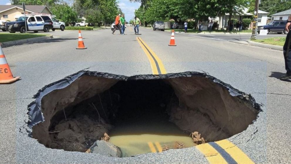
A sinkhole is a hole in the ground caused by the erosion of the soil or bedrock underneath.  They occur when acidic water seeps down and percolates through soluble, or easily dissolved, layers of soil like sandstone, chalk, or limestone.  Over hundreds or thousands of years, more of the rock dissolves while loose soil and sand shifts down to fill the cracks.  For a long time, the land is able to hold its own weight and even the weight of buildings constructed on top of it.  However, as even more of the rock dissolves and becomes empty space, the land becomes too heavy and will collapse suddenly.
For this activity, you will need a pitcher of warm water, sand,
a piece of paper, a cup with a small-medium size hole,
a coffee filter, scissors, and sugar or powdered creamer.
To observe this in our aquifer kits, we’ll start by collecting our materials: a cup, sand, sugar, a paper tube, a pair of scissors, and a coffee filter or sponge.

Frannie starts by cutting a small hole, the same width as the tube, in the bottom of the cup and placing the coffee filter on top of it, keeping it in place with just a little bit of sand.

Next, she puts her tube over the coffee filter and fills the tube a part of the way with sugar.  The sugar represents the soluble rock that will dissolve when the ground gets wet.  While the tube is still in the cup, she pours in the sand so that it comes to about the same height as the sugar.  The sand represents the rest of the ground and will hold the soluble layer in place.


Slowly remove the tube without disturbing the sand or sugar too much and then pour more sand on top, just enough so that none of the sugar is showing.  Carefully pick up the cup and place the bottom into the water and in just a few moments, the water will infiltrate the sand and sugar, dissolving the sugar and creating our sinkhole.

Check out this cool graphic to see what's happening inside the cup!

Graphic by PBS

Wednesday, May 3, 2017

It's Water-Wise Wednesdays with Frannie the Fish! [Awesome Aquifer Kit: Erosion and Weathering}

This week in Frannie’s exploration of the Awesome Aquifer Kit is all about the concept of erosion and weathering.

Photo credit: howtosmile.org
Weathering is the slow destruction or wearing away of soil or rock which is followed by the process of erosion, where the broken particles are then carried away.  This is a very important concept for groundwater and it can happen in two ways: mechanical weathering or chemical weathering.

Mechanical weathering is when rock or soil is physically broken down by constant exposure to flowing or moving water.

Imagine a river that’s moving quickly, picking up sand from the beaches and carrying it downstream.  That’s an example of the beach being mechanically broken by the stream, which carries the sand downstream and makes those beaches smaller.  The same thing can happen underground where, as water slowly flows and picks up particles of soil or rock, the land might get worn down and even sink slightly. 
 
Photo credit: USGS
If the sinking of the land occurs over a long period of time, we call that subsidence.

Chemical weathering is when the rock or soil mixes with the water and dissolves to become a new substance.

This usually happens when polluted rain seeps down into a carbonate type of bed rock.  The acidic water comes into contact with the basic soil and changes the chemistry of the rock so that it breaks down and forms new particles that move with the water flow.


Photo credit: ABC News
It is this kind of weathering and erosion that is usually the cause of sinkholes, a type of sudden natural disaster that results with a large hole in the ground.  Frannie will show us more about sinkholes next week.

Wednesday, April 19, 2017

It’s Water-Wise Wednesdays with Frannie the Fish! {Awesome Aquifer Kit: Exploring Permeability}

This week in Frannie’s exploration of the Awesome Aquifer Kit is all about exploring the key concept of permeability.
For this experiment, you will need water,
a syringe, a timer, sand, and gravel.
Permeability is the ability of a sediment to transmit water.  In other words, permeable materials allow water to easily pass through it and impermeable materials do not let the water move through them.


We’re going to test the permeability of sand and gravel to discover which one is more permeable.

First, we will make a hypothesis about which material water will travel through the fastest.  Frannie thinks water will travel through gravel more quickly than sand.

Now we’re going to take apart the syringe and fill up the inside with gravel.  We’ll measure out one ounce (oz) of water with a small measuring cup and pour the water into the syringe, careful to hold it over a cup so it doesn’t spill everywhere.  For extra fun, we can time it with a stopwatch and see how long the water takes to go through the gravel.

Water flows quickly through the empty syringe on the left, a little more slowly
through the gravel in the middle, and very slowly through the sand on the right.
Next, we’ll empty and dry the syringe before filling it with sand and, again, watching how long it takes 1 oz of water to move through it into our cup.  Does the water move faster or slower than the gravel?

Frannie has found that the water moves faster through the gravel than it does the sand which means that the gravel is more permeable. She was right!

Permeability and porosity are related.  Materials with more open space can hold more water.  More space also provides a quicker flow of water through the material. Materials that have a higher porosity also tend to have higher permeability.  Clays, however, have a very low permeability but are very porous which means they can hold a lot of water but they won’t release it very quickly.  Clay and harder materials that also can’t transmit water very quickly, like shale and granite, are called impermeable layers.

Wednesday, April 5, 2017

It’s Water-Wise Wednesdays with Frannie the Fish! {Awesome Aquifer Kit: Discover Porosity}

This week in Frannie’s exploration of the Awesome Aquifer Kit is all about discovering the key concept of porosity.
For this activity, you 'll need sand, gravel, a syringe, a small cup, water,
 and a towel.  Frannie predicts that gravel is more porous than sand.

Porosity, in hydrogeology, is the capacity of rock, sand, soil, or other sediments to hold water.  We can measure it through the ratio of the volume of empty space in a particular sentiment to the total volume of the sediment.

We’re going to test the porosity of gravel and sand to discover which one is more porous.

First, we’re going to find out the volume of an empty plastic cup by filling up our syringe to the 35 cubic centimeter (cc) line.  Dispense the water from the syringe into the cup until it’s full to the rim.  Subtract the amount of water left in the syringe from the starting amount of 35cc and record this value.  Frannie found that her cup holds 30 cc.

Empty and dry the cup and then fill it with dry gravel. Fill the syringe again with 35 cc and dispense that water into the cup with gravel.  Subtract the amount left in the syringe from the starting amount of 35cc and record this value.  Frannie found that the cup with gravel holds 17 cc of water.

Empty and dry your cup before filling it with sand. Next fill the syringe with 35 ccs and dispense that water into the cup.  Subtract the amount left in the syringe from the starting amount of 35cc and record this value.   Frannie’s cup with sand holds 12 cc of water.

Fannie discovered that the gravel is able to hold more water and is more porous than sand.

To find the porosity of each material, we first have to determine the volume of material in each cup.  The volume of the sand or gravel in the cup will be equal to the volume of the water the cup can hold when full.  So the volume of our gravel and sand is 30 cc.

Remember that porosity is just the ratio of empty space over sediment so our porosity for gravel is p=17 cc/35 cc = .48 = 48%

Our experimentally determined porosity for sand is p=12 cc/35 cc = .34 = 34%
Frannie was right! Gravel is more
porous than sand!