Showing posts with label groundwater model. Show all posts

Tuesday, February 27, 2018

BLOG: GET – The Next Generation of Groundwater Management


by Jim Schneider, PhD, Olsson Associates

While working at the State of Nebraska’s Department of Natural Resources (NDNR), I provided information to the state’s water managers regarding the effect of past, current, and future groundwater use on Nebraska’s aquifers and streams. This required the use of groundwater models, which are numerical representations of these stream/aquifer systems. 
While groundwater models can be extremely useful, they are technically cumbersome and traditionally require extensive financial or human resources to receive information. Unfortunately, water resources management agencies typically don’t have the resources available to get the most out of their models.

Here are two contrasting situations that illustrate this point. 

First, an extensive amount of financial resources had gone into developing and completing a model simulation. The NDNR faced a deadline for an annual report, and information from the simulation was statutorily required to be incorporated into this report. The information dramatically changed the perspective on the level of development in a large portion of Nebraska. A review completed after the report was published revealed the model simulation was an outlier, and additional analysis refined the results. The damage to the public trust took years to overcome.

In the second situation, the State of Nebraska faced litigation over a violation of an interstate compact. In response, a team of scientists and planners spent years completing hundreds of model simulations, and their work revealed the accounting system used to identify an overuse was partially flawed and artificially inflated Nebraska’s overuse. The information uncovered by these simulations led to the state creating a plan to ensure it would avoid future violations. The accounting change and compliance plan were ultimately approved by the United States Supreme Court. 

The benefits of using models extensively became abundantly clear, but how to efficiently provide that level of scientific inquiry for situations less dire than Supreme Court litigation was not.

When I moved to Olsson Associates in September 2015, I was able to develop more innovative techniques. Working with clients on a variety of projects, I became convinced that the solution was to provide water managers direct access to their groundwater models. Thus, the Groundwater Evaluation Toolbox (GET) was born. 

GET is truly a paradigm shift in the way groundwater models are used to manage water. It’s now possible for anyone to use groundwater models to answer specific water management questions, in real time, right at their own desk. The software platform empowers water managers with an easy-to-use interface that keeps their groundwater models running as many hypothetical scenarios as desired, again and again. GET is a cloud-based software service provided on a subscription basis, so a client pays once for an unlimited number of runs. For more information on GET please visit get.olssonassociates.com.
__________

Jim Schneider is a Senior Scientist on the Water Resources Team at Olsson Associates, Inc. in Lincoln, Nebraska. www.olssonassociates.com

The views expressed in this blog are those of the author(s) and do not necessarily represent the view of The Groundwater Foundation, its board of directors, or individual members.

Thursday, January 4, 2018

5 Things to Learn About Groundwater with the Awesome Aquifer Kit

by Jennifer Wemhoff, The Groundwater Foundation

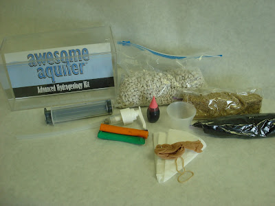
The Awesome Aquifer Kit is one of the most powerful and fun groundwater education tools in our arsenal - we just add water! The Kit's design lets users "see" groundwater in ways they can't in reality.


The Kit includes a step-by-step instruction guide, definitions and explanations, and materials to teach youth and adults alike about:

1. The connection between groundwater and surface water.
The kit's gravel is used to "build" an aquifer and a lake, and water is added to it to learn about terms like recharge, water table, saturated/unsaturated zones, surface water, and discharge.

2. Wells and how they work.
By using a hand pump and tubing, the kit teaches about well siting, pumping, drawdown, depletion, and safe yield. Kids (and adults!) love to pump their aquifers!

3. Porosity and permeability.
Experiments explain different materials' capacity to store water, and have water move through them.

4. How groundwater becomes contaminated and can be cleaned up.
This is perhaps one of the most eye-opening uses of the kit - to illustrate how a contamination reaches groundwater. Food coloring and water create a contaminant plume, and the well is "pumped" to show how the contaminant moves. Activated charcoal and coffee filters are then used to "clean" the contaminated water.


The Awesome Aquifer Kit can be used in a variety of education settings, from a classroom to a water festival and everything in between. Get your Kit today!

Video demonstration
Additional Groundwater Information

Wednesday, May 17, 2017

It’s Water-Wise Wednesdays with Frannie the Fish! {Awesome Aquifer Kit: Sinkholes}

This week in Frannie’s exploration of the Awesome Aquifer Kit is about sinkholes and how they are formed.

A sinkhole is a hole in the ground caused by the erosion of the soil or bedrock underneath.  They occur when acidic water seeps down and percolates through soluble, or easily dissolved, layers of soil like sandstone, chalk, or limestone.  Over hundreds or thousands of years, more of the rock dissolves while loose soil and sand shifts down to fill the cracks.  For a long time, the land is able to hold its own weight and even the weight of buildings constructed on top of it.  However, as even more of the rock dissolves and becomes empty space, the land becomes too heavy and will collapse suddenly.
For this activity, you will need a pitcher of warm water, sand,
a piece of paper, a cup with a small-medium size hole,
a coffee filter, scissors, and sugar or powdered creamer.
To observe this in our aquifer kits, we’ll start by collecting our materials: a cup, sand, sugar, a paper tube, a pair of scissors, and a coffee filter or sponge.

Frannie starts by cutting a small hole, the same width as the tube, in the bottom of the cup and placing the coffee filter on top of it, keeping it in place with just a little bit of sand.

Next, she puts her tube over the coffee filter and fills the tube a part of the way with sugar.  The sugar represents the soluble rock that will dissolve when the ground gets wet.  While the tube is still in the cup, she pours in the sand so that it comes to about the same height as the sugar.  The sand represents the rest of the ground and will hold the soluble layer in place.


Slowly remove the tube without disturbing the sand or sugar too much and then pour more sand on top, just enough so that none of the sugar is showing.  Carefully pick up the cup and place the bottom into the water and in just a few moments, the water will infiltrate the sand and sugar, dissolving the sugar and creating our sinkhole.

Check out this cool graphic to see what's happening inside the cup!

Graphic by PBS

Wednesday, February 8, 2017

It's Water-Wise Wednesdays with Frannie the Fish! {Awesome Aquifer Kit: Groundwater and Surface Water’s Connection}

The Groundwater Foundation has many useful tools to help show how everything we do affects groundwater and how groundwater affects everything we do.  One of Frannie’s favorite tools is the Awesome Aquifer Kit, which lets her get a closer look at what happens to water when it’s deep in the ground.  In this series, Frannie will show us how to use the Awesome Aquifer Kit and what it means in our lives.

This week in Frannie’s exploration of the Awesome Aquifer Kit is all about groundwater and surface water interactions.

First, we have to set up our aquifer by pouring gravel into a clear container and spreading it out evenly.  The gravel represents the land and an unconfined aquifer.  An unconfined aquifer is groundwater that is below porous material like soil, sand, and gravel.

The gravel is flat and we have already added some water to our container.
We'll be using the syringe next time!
Let’s start by slowly pouring water near a wall of the container.  Watch as it infiltrates, or flows from the surface into the ground, and fills th

e spaces between the rocks of the whole container.  Stop pouring when about half of the gravel is saturated.  We can imagine that the pouring water is rain and we are recharging, or refilling, our aquifer.

Do you see that line in the gravel where the water stops? That’s the water table.  The water table is the top of the groundwater and it separates the saturated zone, which is completely full of water, from the unsaturated zone, which as little or no water.

Next, let’s scoop some of the gravel to the side of the container to create a lake.  Surface water is the water that’s above the surface of the land, including lakes, ponds, rivers, streams, and runoff.

The top of the blue line is out water table.
When we add water to the top of our hill, the
water table goes up and fills our lake even more.
We can slowly add some more water, first at the wall close to our hill and second at the wall close to the lake.  Watch the water percolate through the gravel and become groundwater.  The level of the water in the ground rises, but so does the level of water in the lake.  That’s because the groundwater discharges, or flows out, into the lake.


When we add water to the lake, the water table also rises.  When groundwater is located close enough to surface water to be recharged by it, then we can say that the groundwater is under the direct influence of surface water.